Balancing biOdiversity coNservation with Development in Amazonian wetlandS
What we do
We will combine conservation and development issues in scenarios of biodiversity and ecosystem services to find with stakeholders solutions improving preservation.
")

Workpackage 1 – Mapping habitats with remote sensing, in situ data, and hydrological modeling
Improving habitats mapping from remote sensing : a primordial step for allowing us to scale up existing biodiversity data sets and to evaluate the potential impacts of regional drivers such as climate, land use intensification, and dams upon wetland habitats.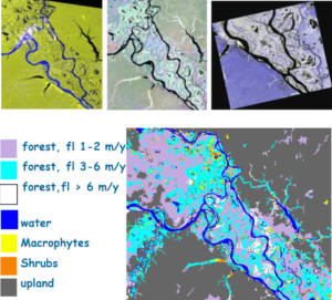
Vegetation/inundation mapping of the entire lowland Amazon basin is available (Hess et al, 2015), but at a spatial resolution (~90 m) and temporal frequency (2 dates) insufficient for biodiversity scenarios; fine-scale mapping (~30m) is available only for a small number of sites, owing to the large number of scenes and dates required for inundation period mapping, and to the lack of cloud-free optical imagery.
- We will explore synergies between multidate optical and radar sensors to improve methods for capturing spatiotemporal variability of floodplain habitats.
- Lidar data from GEDi will be explore to better detecting vegetation structure and improve Digital elevation models
Mapping water optical properties and relate it with phytoplankton biomass is appraised by chlorophyll-a, phytoplankton taxonomy (functional groups), and support the analysis of fish-phytoplankton relationships.
Phytoplankton production in floodplain lakes is fed by the nutrient input of river waters during rising water, but increased phytoplankton blooms occur when suspended material has settled, allowing light to penetrate into the water column [17].Increased nutrient inputs from humans or cattle on or near the floodplain can contribute to increased phytoplankton biomass, eutrophication, and shifts in assemblage diversity toward toxic Cyanobacteria.
- We will gathered field data at contrasted hydrological seasons and relate these data with multi-spectral images from Sentinel-2 satellite to map seasonal chlorophyll-a concentrations during 2019 at 30 m scale in focus sites using and a semi-analytical approach to extend the mapping to the Study Region using Sentinel-3 (300 m).
- Because the phytoplankton community of Amazonian whitewater floodplains is mainly controlled by light availability, remote sensing of light availability can potentially be applied as a surrogate to map multi-temporal phytoplankton biodiversity at regional scale. To test the feasibility of this approach, we will use optical, limnological, and phytoplankton taxonomy measurements collected over the past decade in Amazonian floodplain lakes to develop a phytoplankton community model based on water transparency.
WP2 - Interactions between biodiversity, habitats, hydrology and management
Objectives
We will combine existing information, open access data, data derived from remote sensing and hydroclimatic modeling, new field data and species distribution model to understand how Ecosystem Structure and Function variables (vegetation cover, inundation period, hydrologic connectivity, water quality), fisheries management regimes, and projected hydroclimatic change affect biodiversity and provisioning services of floodplain forests, fish, phytoplankton.
- Understanding the compositional heterogeneity of tree floras and above-ground carbon stocks across the inundation gradient using all georeferenced várzea floodplain inventories (> 350 available).
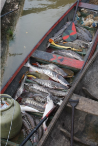
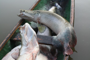
- Assess the network of fish-fruit interactions for the most frugivorous, commercially valuable fish species using stomach contents and local traditional ecological knowledge
- Assessing the effects of local fisheries and fisheries management In the Jurua floodplain, around 80 lakes currently fall under a co-management protocol implemented by local communities and include lakes where commercial fishing is allowed, lakes where only subsistence fishing is allowed and lakes where no fishing is allowed. Taking advantage from this unique natural experiment we will characterize lake foodwebs across treatments associated with different levels of lake protection, and examine the distribution and relative abundance of commercially valuable fish species (and several endangered species (giant river otters, turtles, dolphins and manatees) across lake protection status. This will be primarily based on environmental DNA metabarcoding which uses high-throughput sequencing of barcode genes from bulk DNA samples, that are then compared to reference databases using bioinformatics.
- Evaluate the relationship between hydrologic connectivity and fisheries yields. Floodplain fishery yields occur mainly during the dry seasons in floodplain lake systems, which comprise networks of lakes and channels of varying sizes which are surrounded by varied vegetative stands and are hydrologically connected to the main river channel. Dry-season lake habitat selectivity by fish depends on lake size, depth, surrounding vegetation, and degree of connectivity with the river channel, thus explaining variability in fish biomass in floodplain lakes. We will collect daily data on household fishing activities for one year to model household fish yields as a function of fishing effort, lake characteristics (depth, area), surrounding habitat type, and lake system hydrological connectivity at the Juruá Site.
- Appraise local to regional impacts, prioritizing areas for protected status, assessing threats to those areas, and predicting species distributions in unsurveyed areas through Species Distribution Modelling
Copyright : M.P. Bonnet, J.E. Hawes
WP3 - Participatory modeling of multiscale scenarios: an agent-based approach
Objectives
Engaging smallholders and stakeholders at looking for solutions in fisheries management and land use strategies, enabling preservation of biodiversity and fundamental ecosystem services, such as food security, water quality or carbon storage in Amazon floodplain environments under different hydroclimatic scenarios
- Learning about fishermen and farmers practices and collectively understanding their interactions between
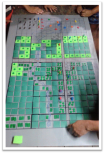 ecological dynamics (vegetation growth, soil erosion, biophysical conditions, fish dynamics). Together with smallholders (fishermen, farmers) we will build a role-playing game (RPG) where actors themselves present their strategies and opinion and are informed of those of other actors, thus progressively sharing a common representation of the floodplain socio-ecosystem. Questionnaires administered and game-playing sessions in a set of contrasted communities will permit to calibrate the RPG rules.
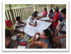
- Playing scenarios in a context of hydroclimatic changes: Once calibrated the RPG will be converted into an agent-based model (ABM) to explore several scenarios in terms of management under several climatic projections in a set of contrasted communities. Scenarios will be compared using a set of indicators previously validated with the participants, such as inco me, fish stock renewal and biodiversity, and food security. These playing-ABM sessions will allow a better collective understanding of the possible management implications and an assessment of their sustainability as the climate changes.
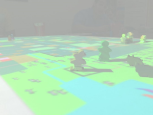
- Upscaling at a more regional scale:Based on the ABM-playing sessions we will construct an autonomous agent-based modelling system to the scale of the Curuai system. Once calibrated, this system could serve as a support to improve fisheries management in the floodplain and its articulation with other important activities such as cattle ranching and agriculture.
WP 4 - Management, communication, results dissemination, data management
Objectives
Our goal is to strengthen the dissemination of our research to civil society, and to make our data and results accessible to the research community and other stakeholders.
Monitoring of research and production of communication tools (brochures, videos, conferences) for different audiences (researchers, actors, decision-makers).
Implementation of an interoperable platform for the provision of data following the FAIR approach, using opensource resources.
Our project will also contribute to GBIF database