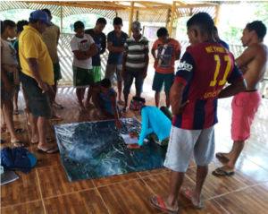
Water bodies’ participatory mapping with fishers in a riverine community (Photo: Almir Lima).
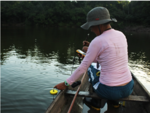
Carolina Freitas taking depth measurements in a floodplain lake (Photo: Clara Machado)
As part of the WP2 activities, with focus upon assessing the effects of hydrological connectivity on floodplain fisheries of Amazonian whitewater rivers, Carolina Freitas carried out a first field expedition during September-October (six weeks), to collect data in floodplain lakes and fishing communities. Carolina surveyed 40 floodplain lakes, spread along ~ 600 km of the Juruá River. In each lake, she took geographic coordinates and depth measurements every ~50m, using a portable sonar, and recorded general information about the lake, such as surrounding vegetation physiognomy; presence of macrophytes; water color; main water connections to the river; and fishing management rules. In parallel, Carolina carried out a participatory mapping in 17 riverine communities, to locate the main floodplain lakes of the study region and all water connections between them and the river. In total, 531 water bodies were mapped, including lakes, streams and other aquatic habitats. Data obtained in this field expedition will be linked to information coming from a fishing monitoring previously carried out in the study area. Statistical analysis will be performed using all available data in order to assess the effects of hydrological connectivity, and others variables, on floodplain fisheries.

